
- Type in and search for cities, addresses, and land marks within Flash
- Different views including satellite imagery
- Reverse Geo-coding: move the map and the address of where you are displays on the bottom
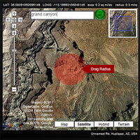
- Added my own interactive layer “Drag Radius”
 see it
The task at hand was to build an “Area Selector” in Flash. You could go to an address, drag a highlight over the area, and then get the coordinates and size. Future plans were to hook into databases with coordinate information and extract other data for marketing purposes.
Currently it shows LAT/LONG/area/radius. Adding the area and radius was not easy. It has to account for the zoom level. So, a 1″ radius could be 1/10 sq Mile, or it could span half of the planet, depending on your zoom level. The other feature I added was Reverse Geo-coding. The center point reveals the address of the building underneath (if there is one). Dragging the map more triggers address lookups on each move.
The Google Maps API for AS3 is here: http://code.google.com/apis/maps/documentation/flash/
You have to sign up for an API key, but its well worth it.